


02/09/2026
Met Éireann Reveals 2026/27 Storm Names As Service Marks 90th Year
Ireland's weather service, Met Éireann, has unveiled the names for the 2026/27 storm season, which began on 1 September 2026, and runs until 31 August 2027.
Created in collaboration with the UK Met Office and the Netherlands' KNMI, the 21-strong list includes seven names provided by each national service.
Met Éireann's contributions are Austen, Evelyn, Kilian and Miriam — chosen to mark the meteorological service's 90th anniversary — and Heather, Laoise and Phelim, drawn from public suggestions in 2025. The full list is: Austen, Boelo, Chloe, Dano, Evelyn, Finn, Gwendolyn, Heather, Ivy, Jade, Kilian, Laoise, Miriam, Nicola, Olaf, Phelim, Ruban, Shaun, Theo, Vesna, Wende. In line with the US National Hurricane Center convention, the letters Q, U, X, Y and Z are omitted.
Commenting on the announcement, Eoin Sherlock, Head of Forecasting Division in Met Éireann, said: "Naming storms helps Met Éireann in our mission to protect life and property through the provision of world-class weather, climate, and flood services. Using consistent names and communications allows us and other public safety organisations to increase awareness of severe and impactful weather alongside our weather warnings.
"We know that naming storms makes it easier for people to track important and up to date forecast and safety-related information as we can see from the levels of traffic and activity through our website and across social media platforms during storm events.
"2026 marks the 90th anniversary of the establishment of the Irish Meteorological Service and we are proud to be able to recognise some of the significant contributors to our history in the list of storm names this year, such as the first director of the Service in 1936, Austen Nagle, and the first woman to hold an operational role as a meteorological officer, Miriam Lyons.
"As we approach the start of the new storm season, we take the opportunity to encourage to the public to engage with relevant forecasts and safety information during storms and all other extreme weather events."
A storm will be named when medium or high impacts are expected in any of the partner countries. The service that first anticipates the greatest effects, or that is likely to be impacted first, assigns the name. Weather warnings for wind, rain or snow may accompany a named storm and are issued using a blend of numerical thresholds and predicted impacts. Up-to-date forecasts and alerts are available via the Met Éireann website and app.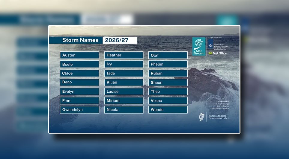 Met Éireann and the UK Met Office have jointly named storms since 2015, with KNMI joining the programme in 2019. Other meteorological services across Europe and in the US also name significant weather systems. Once any national service names a system, that name is retained by all others — including ex-hurricanes designated by the US National Hurricane Center. Notably, Charley (25 August 1986) and Ophelia (16 October 2017) were retained when they crossed the Atlantic and had major impacts in Ireland.
Holly Clements, Head of Warnings and Guidance at the UK Met Office, said: "For more than a decade, storm naming has helped us communicate the risks from severe weather more effectively. A named storm provides a clear focus for forecasts and warnings, helping more people understand the potential impacts and take action to protect themselves, their families and their property."
Looking back at the 2025/26 season, five named storms affected the region: Amy (October), Claudia (November, named by Spain's AEMET under the south-western Europe convention), Bram (December), Chandra (January) and Dave (April). The season featured vigorous Atlantic cyclones, with the most extreme winds in October, the lowest pressure in January, the wettest conditions in November and the final listed impacts in April.
Storm Amy delivered the strongest winds, with sustained violent storm force winds of 111 km/h and gusts up to 148 km/h at Malin Head. Claudia was the wettest, bringing a daily total of 66.9 mm at Johnstown Castle and producing the season's highest individual wave at 21.1 m at Buoy M5 off the south Wexford coast. Bram was unusually warm for December, reaching 17.2 °C at Phoenix Park. Chandra was the deepest storm, with mean sea level pressure down to 958.4 hPa and gusts of 130 km/h at Malin Head, second only to Amy for wind strength. Dave in early April brought storm force winds, gusts to 111 km/h and 38.6 mm of daily rainfall.
Across 11 storm-naming seasons since 2015/16, Ireland has seen 87 named storms, with considerable year-to-year variability. The busiest was 2023/24 with 14 named storms affecting Ireland. However, 2015/16 recorded the greatest number reaching Storm Force 10 or higher, when nine of the 11 named storms produced sustained winds of Storm Force 10 or greater at coastal stations. The quietest was 2022/23 with four. The most recent hurricane force winds observed on land occurred during Storm Éowyn on Friday 24 January 2025, with gusts up to 184 km/h — Ireland's highest on record, surpassing the 182 km/h set at Foynes, Co Limerick in 1945.
Met Éireann thanked the Irish public for their enthusiastic name suggestions in 2025 and said the longlist will continue to inform future seasons. The service — Ireland's National Meteorological Service under the UN's World Meteorological Organization — monitors, analyses and predicts weather, climate and flooding to protect life and property and support wider well-being. Its vision is "Ready for Change – preparing Ireland for changing weather and climate."
Further information on warnings, storm names and historical extremes is available on Met Éireann's website and through its app, including the Storm Centre and Major Weather Events resources.
Created in collaboration with the UK Met Office and the Netherlands' KNMI, the 21-strong list includes seven names provided by each national service.
Met Éireann's contributions are Austen, Evelyn, Kilian and Miriam — chosen to mark the meteorological service's 90th anniversary — and Heather, Laoise and Phelim, drawn from public suggestions in 2025. The full list is: Austen, Boelo, Chloe, Dano, Evelyn, Finn, Gwendolyn, Heather, Ivy, Jade, Kilian, Laoise, Miriam, Nicola, Olaf, Phelim, Ruban, Shaun, Theo, Vesna, Wende. In line with the US National Hurricane Center convention, the letters Q, U, X, Y and Z are omitted.
Commenting on the announcement, Eoin Sherlock, Head of Forecasting Division in Met Éireann, said: "Naming storms helps Met Éireann in our mission to protect life and property through the provision of world-class weather, climate, and flood services. Using consistent names and communications allows us and other public safety organisations to increase awareness of severe and impactful weather alongside our weather warnings.
"We know that naming storms makes it easier for people to track important and up to date forecast and safety-related information as we can see from the levels of traffic and activity through our website and across social media platforms during storm events.
"2026 marks the 90th anniversary of the establishment of the Irish Meteorological Service and we are proud to be able to recognise some of the significant contributors to our history in the list of storm names this year, such as the first director of the Service in 1936, Austen Nagle, and the first woman to hold an operational role as a meteorological officer, Miriam Lyons.
"As we approach the start of the new storm season, we take the opportunity to encourage to the public to engage with relevant forecasts and safety information during storms and all other extreme weather events."
A storm will be named when medium or high impacts are expected in any of the partner countries. The service that first anticipates the greatest effects, or that is likely to be impacted first, assigns the name. Weather warnings for wind, rain or snow may accompany a named storm and are issued using a blend of numerical thresholds and predicted impacts. Up-to-date forecasts and alerts are available via the Met Éireann website and app.
Holly Clements, Head of Warnings and Guidance at the UK Met Office, said: "For more than a decade, storm naming has helped us communicate the risks from severe weather more effectively. A named storm provides a clear focus for forecasts and warnings, helping more people understand the potential impacts and take action to protect themselves, their families and their property."
Looking back at the 2025/26 season, five named storms affected the region: Amy (October), Claudia (November, named by Spain's AEMET under the south-western Europe convention), Bram (December), Chandra (January) and Dave (April). The season featured vigorous Atlantic cyclones, with the most extreme winds in October, the lowest pressure in January, the wettest conditions in November and the final listed impacts in April.
Storm Amy delivered the strongest winds, with sustained violent storm force winds of 111 km/h and gusts up to 148 km/h at Malin Head. Claudia was the wettest, bringing a daily total of 66.9 mm at Johnstown Castle and producing the season's highest individual wave at 21.1 m at Buoy M5 off the south Wexford coast. Bram was unusually warm for December, reaching 17.2 °C at Phoenix Park. Chandra was the deepest storm, with mean sea level pressure down to 958.4 hPa and gusts of 130 km/h at Malin Head, second only to Amy for wind strength. Dave in early April brought storm force winds, gusts to 111 km/h and 38.6 mm of daily rainfall.
Across 11 storm-naming seasons since 2015/16, Ireland has seen 87 named storms, with considerable year-to-year variability. The busiest was 2023/24 with 14 named storms affecting Ireland. However, 2015/16 recorded the greatest number reaching Storm Force 10 or higher, when nine of the 11 named storms produced sustained winds of Storm Force 10 or greater at coastal stations. The quietest was 2022/23 with four. The most recent hurricane force winds observed on land occurred during Storm Éowyn on Friday 24 January 2025, with gusts up to 184 km/h — Ireland's highest on record, surpassing the 182 km/h set at Foynes, Co Limerick in 1945.
Met Éireann thanked the Irish public for their enthusiastic name suggestions in 2025 and said the longlist will continue to inform future seasons. The service — Ireland's National Meteorological Service under the UN's World Meteorological Organization — monitors, analyses and predicts weather, climate and flooding to protect life and property and support wider well-being. Its vision is "Ready for Change – preparing Ireland for changing weather and climate."
Further information on warnings, storm names and historical extremes is available on Met Éireann's website and through its app, including the Storm Centre and Major Weather Events resources.
Latest Northern Ireland News
02 September 2026
Judge-Led Review Ordered Into Parades Commission After Drumcree Ruling
The Secretary of State for Northern Ireland, Sir Chris Bryant, has ordered an independent, judge-led review of the Parades Commission's decision-making procedures, following last week's High Court ruling on the Drumcree parade. Sir Chris met commissioners this morning to discuss the body's response to the judgment.
Judge-Led Review Ordered Into Parades Commission After Drumcree Ruling
The Secretary of State for Northern Ireland, Sir Chris Bryant, has ordered an independent, judge-led review of the Parades Commission's decision-making procedures, following last week's High Court ruling on the Drumcree parade. Sir Chris met commissioners this morning to discuss the body's response to the judgment.
02 September 2026
Givan Unveils New Approach To Integrated Education
Education Minister Paul Givan has published a Department of Education Position Paper on Integrated Education, setting out clarification on the legal framework and measures to support schools considering moving to integrated status.
Givan Unveils New Approach To Integrated Education
Education Minister Paul Givan has published a Department of Education Position Paper on Integrated Education, setting out clarification on the legal framework and measures to support schools considering moving to integrated status.
02 September 2026
Driver Killed In Two-Vehicle Crash On Lisburn's Belfast Road
The Police Service of Northern Ireland has confirmed a man has died following a road traffic collision in Lisburn. Detective Inspector Stewart from the Police Service's Collision Investigation Unit said: "We received a report at approximately 5.
Driver Killed In Two-Vehicle Crash On Lisburn's Belfast Road
The Police Service of Northern Ireland has confirmed a man has died following a road traffic collision in Lisburn. Detective Inspector Stewart from the Police Service's Collision Investigation Unit said: "We received a report at approximately 5.
02 September 2026
Met Éireann Reveals 2026/27 Storm Names As Service Marks 90th Year
Ireland's weather service, Met Éireann, has unveiled the names for the 2026/27 storm season, which began on 1 September 2026, and runs until 31 August 2027. Created in collaboration with the UK Met Office and the Netherlands' KNMI, the 21-strong list includes seven names provided by each national service.
Met Éireann Reveals 2026/27 Storm Names As Service Marks 90th Year
Ireland's weather service, Met Éireann, has unveiled the names for the 2026/27 storm season, which began on 1 September 2026, and runs until 31 August 2027. Created in collaboration with the UK Met Office and the Netherlands' KNMI, the 21-strong list includes seven names provided by each national service.
02 September 2026
Wanted Man Arrested In Claudy
A 32-year-old man has been detained by the District Support Team; he is suspected of multiple driving offences and theft. Police in L'Derry arrested the man on Tuesday 1 September, at around 3.40pm in licensed premises in the Main Street area of Claudy.
Wanted Man Arrested In Claudy
A 32-year-old man has been detained by the District Support Team; he is suspected of multiple driving offences and theft. Police in L'Derry arrested the man on Tuesday 1 September, at around 3.40pm in licensed premises in the Main Street area of Claudy.
02 September 2026
Guy Accuses Education Minister Of Ignoring Legal Duty On Integrated Education
Alliance Education spokesperson Michelle Guy MLA has criticised the Department of Education's Position Paper on Integrated Education, published on 1 September, arguing it underscores what she describes as the Education Minister's disregard for his legal obligation to encourage and facilitate integrated education.
Guy Accuses Education Minister Of Ignoring Legal Duty On Integrated Education
Alliance Education spokesperson Michelle Guy MLA has criticised the Department of Education's Position Paper on Integrated Education, published on 1 September, arguing it underscores what she describes as the Education Minister's disregard for his legal obligation to encourage and facilitate integrated education.
02 September 2026
Burrows Backs Judge-Led Probe, Urges Wider Remit For Parades Commission
Ulster Unionist Party leader Jon Burrows MLA has endorsed the Secretary of State's decision to initiate a judge-led review of the Parades Commission, while calling for a significantly broader remit and greater transparency from the process. Jon Burrows MLA said: "An independent, judge-led review is the right course of action.
Burrows Backs Judge-Led Probe, Urges Wider Remit For Parades Commission
Ulster Unionist Party leader Jon Burrows MLA has endorsed the Secretary of State's decision to initiate a judge-led review of the Parades Commission, while calling for a significantly broader remit and greater transparency from the process. Jon Burrows MLA said: "An independent, judge-led review is the right course of action.
02 September 2026
SONI Strategy To Advance Northern Ireland’s Energy Transition
Achieving the region's renewable energy and net zero ambitions will require a whole-system and whole-society effort, driven by collaboration, innovation and shared commitment across government, industry, regulators, communities and the public.
SONI Strategy To Advance Northern Ireland’s Energy Transition
Achieving the region's renewable energy and net zero ambitions will require a whole-system and whole-society effort, driven by collaboration, innovation and shared commitment across government, industry, regulators, communities and the public.
01 September 2026
Teenage Boy Charged with Dungannon Murder
Detectives from the Police Service of Northern Ireland's Major Investigation Team have charged a 16-year-old male in connection with the death of a man in Dungannon on Saturday, 29th August 2026. The teenager has been charged with murder, two counts of attempted murder, and threats to kill.
Teenage Boy Charged with Dungannon Murder
Detectives from the Police Service of Northern Ireland's Major Investigation Team have charged a 16-year-old male in connection with the death of a man in Dungannon on Saturday, 29th August 2026. The teenager has been charged with murder, two counts of attempted murder, and threats to kill.
01 September 2026
Givan Opens Consultation On Laws Backing Phone-Free Schools
Education Minister Paul Givan has begun a 12-week public consultation on plans to legislate for mobile phone-free schools, alongside issuing strengthened guidance that sets a clear expectation schools should be phone-free by default.
Givan Opens Consultation On Laws Backing Phone-Free Schools
Education Minister Paul Givan has begun a 12-week public consultation on plans to legislate for mobile phone-free schools, alongside issuing strengthened guidance that sets a clear expectation schools should be phone-free by default.
-




 Northern Ireland WeatherToday:It will be mostly cloudy with outbreaks of rain, the rain occasional heavy and persistent with cloud lowering onto the hills. Breezy at times around Irish Sea coasts. Maximum temperature 19 °C.Tonight:Outbreaks of rain or showers will push northwards during the evening. Drier and clearer conditions returning from the west overnight. Breezy around the coast. Minimum temperature 14 °C.